Learn about the trail, permits, and gear in this detailed guide to hiking the incredible Wave in Arizona.

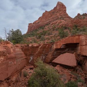
Most people have seen photos of hiking The Wave in Arizona – a gorgeous red sandstone formation along the Utah/Arizona border near Kanab in the Vermilion Cliffs National Monument. The Wave is an incredible trail that should be on every hiker’s bucket list, and in this trail guide, we share everything you need to know before trying to hike the Wave.
Due to the overwhelming popularity of the site, the Bureau of Land Management limits foot traffic into the Canyon, thus preserving the integrity and beauty of The Wave. For years, access was limited to only 20 lucky people a day, but in February 2021, the BLM increased the daily hiking quota to 64 people/day. Of those, 48 get permits in the advance lottery and 16 permits are awarded in the daily lottery.
It’s still hard to find yourself one of the lucky ones to receive a permit for the site, despite the increased quota, simply because there are so many people who want to experience The Wave. In 2018 alone, there were approximately 168,317 applicants, and with only 7,300 people allowed access, that’s a 4.3% success rate.
With that said, your best chance at an opportunity to hike the Wave is to be informed. In this guide to the Wave, we share information on the advanced Wave lottery, last-minute daily lottery permits, and recommended gear, as well as a trip report to help you plan for your visit.
Contents
Hiking The Wave: Trail Basics
Most people access the Wave from the Wire Pass Trailhead located in the North Coyote Buttes permit area of the Vermilion Cliffs National Monument. The moderate 6-mile hike consists primarily of sand and red rock. Part of the trail is cross-country, so you should have a map and a basic understanding of navigation skills, especially given the harsh, dry desert heat conditions.
- Trail Type: Out-and-back
- Length: 6 miles
- Elevation Change: +/- 400 feet
- Dogs Allowed: Yes, for an additional $7/per dog/per day (They must be under your control at all times and you are required to pack out their waste)
- Best Season: Spring and Fall (best weather)
- Time: 2-4 hours
- Permit Required: YES
- Water Availability: None

Here is a Google Map of The Wave hike.

How to Get a Permit for The Wave
There are two ways to obtain a permit for hiking The Wave in Arizona. If you can plan ahead, you should try your luck in the advanced online lottery that happens on the first of each month, 4 months in advance. However, if your trip is last minute or you are unsuccessful in the online Wave lottery, you can also enter the daily lottery which requires you to download the recreation.gov app to your phone and enter a virtual lottery (previously this lottery was held in person).
Only 64 people are issued permits for the Wave each day. 48 people (or 12 groups, whichever comes first) are awarded permits through the online lottery system. The other 16 people (or 4 groups, whichever comes first) are awarded permits through the walk-in lottery.
The advanced online lottery costs $9 per application and is non-refundable, even if you are unsuccessful.
Advanced Online Lottery for The Wave
To apply for a Wave permit, start at the Coyote Buttes North lottery page on the Recreation.gov website. Applications for the online lottery open at 12pm Mountain Time on the 1st of the month, four months before your desired hiking month. The table below indicates when you must apply depending on when you want to hike.

Here’s an example of how this works. Let’s say you want to hike The Wave sometime in May. You must submit your online application sometime between January 1st and January 31st. When applying, you are allowed to enter three different hiking dates for the month of May. The lottery then takes place on the morning of February 1st, after which you will be notified by email whether or not you were successful. If you were successful, then you have 14 days to confirm and pay for your permit ($7/person) online. If you don’t confirm during this time, your permit is released back into the system.
March through November are the most competitive months for permits while December through February have better odds. It’s important to note here that while the odds of receiving a permit are higher in the middle of winter, the odds of poor weather, unpassable roads, and a snow-covered Wave are also higher.
Finally, each individual is only allowed to submit one application per month and these permits cannot be sold or transferred. If you end up submitting more than one, you will be disqualified. You can name up to three specific alternate permit holders when you apply for the lottery in the event that you aren’t able to make the dates for your permit.
Daily Lottery for the Wave (NEW AS OF 2022):
If you are unsuccessful in the advance online lottery or want to spontaneously hike The Wave, your other option is to enter the daily lottery via the recreation.gov mobile app.
Applications must be submitted two days before your hike during the lottery application window (6am – 6pm). You can only apply on the mobile app – a desktop computer will not work.
Permits will only be available to people using the app within an intentionally set geographic fence. In order to apply for a permit, you will need to be in the following areas:
- Arizona: Page, Greenhaven, Marble Canyon, Vermilion Cliffs, Jacob Lake, White Sage, Fredonia, Moccasin, and the Kaibab Paiute Indian Reservation.
- Utah: Big Water, Paria, Johnson Canyon, Kanab, Mount Carmel, Orderville, Glendale, and East Zion.
The daily online lottery costs $9 per application and is non-refundable, even if you are unsuccessful.
For a full FAQ and additional details on the permit process including the most up-to-date information, visit the Vermilion Cliffs page on the BLM’s website.

What if you don’t get a permit?
Getting a permit for The Wave, whether through the advanced process or daily lottery, is very competitive and only a small percentage of applicants are actually lucky enough to hike The Wave each year. So what if you aren’t one of the lucky ones?
You could apply for a Coyote Buttes South Permit. While this doesn’t grant you access to the famous “wave”, it does allow you to hike in a geologically similar and more remote area of Paria Canyon-Vermilion Cliffs Wilderness complete with sandstone bluffs and wave formations.
There are two trailheads into Coyote Buttes South and both require a 4×4 vehicle to access. Click here for more information and to apply for a Coyote Buttes South permit.
Also remember that the Wave is only one of the incredible hikes in this Southern Utah region. For more tripping planning inspiration, check out these Utah bucket list hikes and read our guide to the best things to do in Kanab, Utah.
Recommended Gear for Hiking the Wave
This is a hot, dusty desert environment with no drinking water. You should be prepared with 3 liters of water at a minimum. I always recommend a daypack with a hydration reservoir for easy drinking. You’ll also want sun protection and good hiking shoes.
The trail is not well-marked and there is no cell phone service. You should be prepared with a good map (you can also get one at the ranger’s station), and if you’re inexperienced with backcountry navigation, you may also want to bring a GPS and communication device. I recommend the Garmin InReach.
Recommended Hiking Packing List
Below are a few of my favorite pieces of day hiking gear and recommendations:


Hiking The Wave: Trip Report
We were lucky enough to make the drive to the Wave trailhead without any problems, even though it had rained the night before. Upon arrival, the ranger gives a spiel on safety and how to navigate the region. As I mentioned, be sure to grab a map since the path to The Wave isn’t well-defined like a typical hiking trail. Afterward, we strapped on our shoes, checked our packs for water/snacks, applied necessary sunscreen, and hit the trail.

To find the main trail you need to cross the road and enter into the river wash, heading back north for a half-mile or so until it winds to the east (where eventually you will see this sign).

After passing the sign to the Coyote Buttes North Area, you will stay to the right (the left goes down to Buckskin Gulch) and you soon find yourself hiking along this sandy/desert terrain.

This is the point in the journey when the map provided by the ranger came in handy. Here, in particular, we headed toward the first big mound off in the distance, just to the right of center in the image.
Once we crossed over the ridge, the landscape changed to hard sandstone (which made it much easier to hike along). There were some signposts along the path leading up to the Wave to help steer us in the right direction. To head in the right direction, look for these types of buttes in the distance, and head towards the two in the middle, passing them just on the right side.

After that pass, the terrain opens up and you’ll see a large rock face in the distance with a fissure/crack vertically down the face…that’s your destination. Other landmarks to look for along the way are white streaks along the sandstone you’re walking on, following that in between two small sand dunes in the distance. Having these small reference points along the way ensured that it was nearly impossible to lose your way (although historically hikers have gotten lost and deaths have occurred due to heat-stress and other related causes, so make sure to bring plenty of water!)
After passing between the small dunes, it’s a final push to reach the site of The Wave. The anticipation and excitement build as you drop down into another river wash and then begin the final climb in the sand to your destination. With the sun blazing down on us and the sweat building up, we couldn’t wait for the moment to arrive and rest, but as soon as we arrived the last thing we wanted to do was sit down. It was time to play and explore.

Thanks to the storm that passed through the night before our adventure, we were lucky to be able to experience this beautiful place in such a setting, with an amazing reflection bouncing off a pool of water right at the entrance (and many other pools throughout the site). This larger wide-lens view of The Wave perfectly depicts the incredible striations of the windblown sandstone.

After passing by the pool of water at the main entrance to the Wave, we looked back on this series of pools that collected water from the storm. The contrast of the red rock and the blue sky was absolutely perfect.

We continued to meander around and through the site for 30 minutes or so before ever stopping for a rest. We soon found ourselves perched up above The Wave and figured that it was the perfect spot to relax and replenish ourselves with food and water.
Now that we were fueled up we were ready for some more exploring. We headed to the top of the sandstone cliffs to the south, catching the vast landscape of the desert in all directions. All in all, we probably spent a good 3 hours at the site to gather as many vantage points as possible of this once in a lifetime visit.

Nearing the end of our journey, we caught an amazing view of The Wave from the south looking north. This just so happened to be the perfect location for us to drop in and snap some pictures of us surfing this desert wave.

The trip to The Wave was epic! To date, we haven’t been to any place in the world as remarkable, serene, and uniquely beautiful as this site. The privacy and exclusivity of this site make it all the better. While it’s tough to get a permit, the lack of crowds makes it that much more enjoyable. In silence, you can admire the awe and wonder of the creative processes of Mother Nature.

Now, years later, as we look back on this trip we wish we had done more with our time there. If you decide to venture further past The Wave, there are a bunch of other cool features worth exploring, including a couple of arches.